
For Buyers
7 min read
Zoning is just the beginning: Understanding planning rules
Welcome to Relab's new series covering essential Due Diligence for Developers, starting with our first article on zoning.
Spotting a site zoned 'mixed housing urban' or 'terrace housing and apartment buildings' in Auckland can feel like striking gold. These zones offer broad development potential, allowing for greater height, more units, and compact urban living…on paper. But the reality is that zoning is just the starting point, and understanding what's actually possible on a site requires going several layers deeper into the planning framework. Let's take a look at how to fully understand the rules of zoning.
Get familiar with the Auckland Unitary Plan, which gives you the zoning blueprint you'll need. It sets key parameters like permitted activities, height limits, setbacks, site coverage, and minimum outdoor living spaces. In short, it defines the rules you'll be playing by.
But even if the zoning looks favourable, other planning layers can significantly constrain (or in some cases enhance) what you can do.
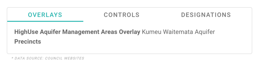
This is where overlays, controls, and designations come in. And if you're not checking these carefully during due diligence, you could end up with a site that's far less developable than you thought.
![Screenshot of Overlay Toggle in Relab]()
Here are three of the most common planning constraints that can catch developers off guard:
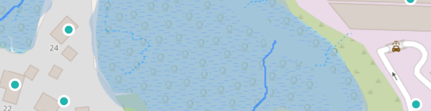
These are environmentally sensitive zones where native flora and fauna are protected. The most common SEA for developers is triggered by wetlands on their property. A SEA can override your base zoning entirely, meaning even if your site is zoned for housing, you may not be allowed to build on part (or all) of it. As planner Michael Campbell explains, "You might find a site that's zoned residential, but it may have a significant ecological area over part or all of it." That could be a fatal flaw to your development feasibility. And natural wetlands? They're currently a complete no-go, destroying them is a 'prohibited activity', no resource consent can be sought.
![Screenshot showing wetlands on Relab]()
Some heritage sites are listed within the unitary plan, but others aren't. Certain properties are protected under the Heritage New Zealand Pouhere Taonga Act and may not be visible in council mapping tools. Even if a building looks modern or unremarkable, always double-check the Heritage NZ register and archaeological records, as if it's protected then demolition or major alteration work may not be an option for you
A road widening designation or infrastructure corridor can eat into your site's footprint. These designations allow council or utility providers to acquire land or restrict development in key transport corridors, so if your site is affected, you may be forced to set buildings back or leave part of the land undeveloped, which can impact density and yield.
Before you run feasibility numbers or submit an offer, get a clear picture of your site's true planning context:
As Campbell Brown Planning puts it, "Good base information is vital", and zoning is just one layer. Understanding everything that sits on top of it is what separates successful developers from those caught out post-purchase.
Stay tuned for the next article in our series: Natural hazards: What flood zones really mean, and get in touch with the team with any questions you may have, we'd love to support you.
Spotting a site zoned 'mixed housing urban' or 'terrace housing and apartment buildings' in Auckland can feel like striking gold. These zones offer broad development potential, allowing for greater height, more units, and compact urban living…on paper. But the reality is that zoning is just the starting point, and understanding what's actually possible on a site requires going several layers deeper into the planning framework. Let's take a look at how to fully understand the rules of zoning.
Why zoning isn't the full story:
Get familiar with the Auckland Unitary Plan, which gives you the zoning blueprint you'll need. It sets key parameters like permitted activities, height limits, setbacks, site coverage, and minimum outdoor living spaces. In short, it defines the rules you'll be playing by.
But even if the zoning looks favourable, other planning layers can significantly constrain (or in some cases enhance) what you can do.
This is where overlays, controls, and designations come in. And if you're not checking these carefully during due diligence, you could end up with a site that's far less developable than you thought.
What to watch out for:
Here are three of the most common planning constraints that can catch developers off guard:
Significant ecological areas (SEAs)
These are environmentally sensitive zones where native flora and fauna are protected. The most common SEA for developers is triggered by wetlands on their property. A SEA can override your base zoning entirely, meaning even if your site is zoned for housing, you may not be allowed to build on part (or all) of it. As planner Michael Campbell explains, "You might find a site that's zoned residential, but it may have a significant ecological area over part or all of it." That could be a fatal flaw to your development feasibility. And natural wetlands? They're currently a complete no-go, destroying them is a 'prohibited activity', no resource consent can be sought.
Heritage protections
Some heritage sites are listed within the unitary plan, but others aren't. Certain properties are protected under the Heritage New Zealand Pouhere Taonga Act and may not be visible in council mapping tools. Even if a building looks modern or unremarkable, always double-check the Heritage NZ register and archaeological records, as if it's protected then demolition or major alteration work may not be an option for you
Road widening and other designations
A road widening designation or infrastructure corridor can eat into your site's footprint. These designations allow council or utility providers to acquire land or restrict development in key transport corridors, so if your site is affected, you may be forced to set buildings back or leave part of the land undeveloped, which can impact density and yield.
Smart next steps:
Before you run feasibility numbers or submit an offer, get a clear picture of your site's true planning context:
- Start a free trial with Relab for a free planning report with permitted and non-permitted activities
- Utilise Relab's consolidated Auckland council zoning, overlays, control and designations tool
- Use Auckland Council's geoMaps tool to identify overlays, controls, and designations
- Check the Heritage New Zealand and archaeological sites register
- Talk to a planner if you see any red flags, or even just to validate your assumptions early
As Campbell Brown Planning puts it, "Good base information is vital", and zoning is just one layer. Understanding everything that sits on top of it is what separates successful developers from those caught out post-purchase.
Stay tuned for the next article in our series: Natural hazards: What flood zones really mean, and get in touch with the team with any questions you may have, we'd love to support you.