

For Agents
4 min read
Understanding Auckland's Infrastructure Capacity: Latest Watercare Map Analysis
Watercare has recently released their latest infrastructure capacity map, providing critical information for Auckland's development community. As Auckland grows, these constraints highlight the delicate balancing act between urban development and infrastructure readiness. Understanding where these bottlenecks exist—and how they might evolve—has become essential for anyone looking to develop or invest in Auckland property.
We've conducting a detailed analysis to pinpoint where development potential is most impacted by infrastructure constraints. These constraints affect:
![]()
Our team compiled this infrastructure analysis using Watercare's infrastructure capacity maps, Auckland Council records, and official government documents as of November 2024. For transparency, we've defined "developable sites" as freehold title properties that:
While this analysis provides a regional overview, please note that:
For the most current information, we recommend contacting:
To further assist property professionals, we’ve integrated Watercare’s Network Capacity Map Overlay into Relab. This new feature includes capacity constraints and expected resolution timeframes and is seamlessly combined with other development overlays such as zoning and planning data.
This integration provides a comprehensive view to help developers and investors see the full picture and make informed decisions. You can learn more about this feature here.
Disclaimer: This infrastructure analysis and visualisation is provided for informational purposes only, This analysis should not be used as the sole basis for investment or development decisions, and users should conduct their own due diligence and seek professional advice before proceeding with any property development or investment decisions.
We've conducting a detailed analysis to pinpoint where development potential is most impacted by infrastructure constraints. These constraints affect:
- 51,651 developable sites with water supply or wastewater service constraints
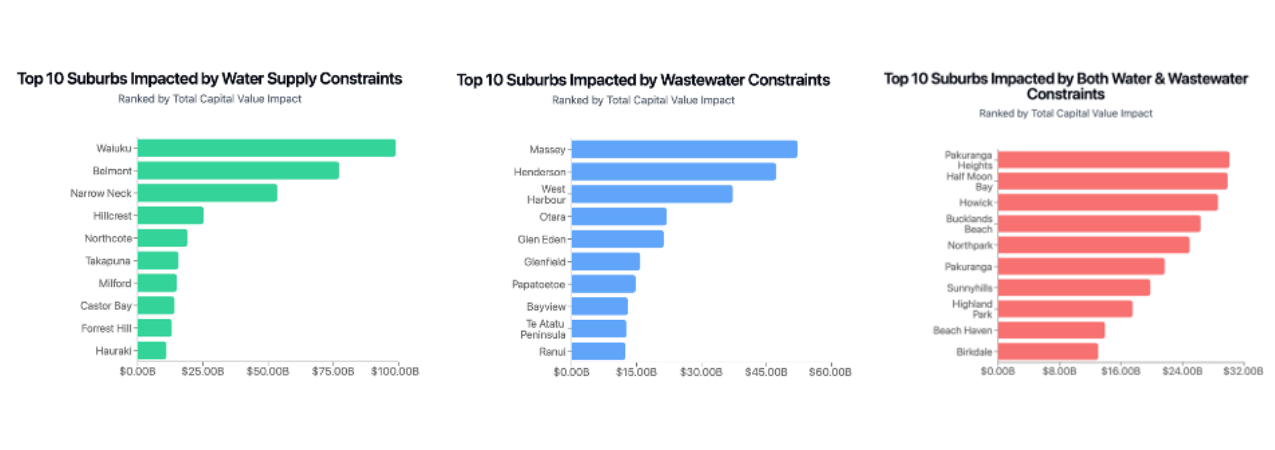
- Key areas include Massey, Henderson, West Harbour, Half Moon Bay, Pakuranga, Howick and more.
- The graphs below highlights the top 10 suburbs with development potential that are impacted by constraints, ranked by capital value.
A Note About Our Analysis
Our team compiled this infrastructure analysis using Watercare's infrastructure capacity maps, Auckland Council records, and official government documents as of November 2024. For transparency, we've defined "developable sites" as freehold title properties that:
- Are zoned for Mixed Housing Suburban, Mixed Housing Urban, or Terrace Housing and Apartment zones
- Have land size between 500 to 4,000 square metres
- Include existing wastewater connection
Important Considerations
While this analysis provides a regional overview, please note that:
- Local network constraints may exist at street level that aren't captured here
- Infrastructure constraints, timelines, and property valuations are subject to change
- The developable status of specific sites should be independently verified
For the most current information, we recommend contacting:
- Watercare (networkcapacity@water.co.nz)
- Auckland Council
- Your property development professionals
New Feature: Network Capacity Map Integration in Relab
To further assist property professionals, we’ve integrated Watercare’s Network Capacity Map Overlay into Relab. This new feature includes capacity constraints and expected resolution timeframes and is seamlessly combined with other development overlays such as zoning and planning data.
This integration provides a comprehensive view to help developers and investors see the full picture and make informed decisions. You can learn more about this feature here.
Additional Resources
- Watercare Press Release https://www.watercare.co.nz/home/about-us/latest-news-and-media/building-for-auckland-s-growing-water-needs
- Network Capacity in Auckland https://www.watercare.co.nz/builders-and-developers/consultation/network-capacity-in-auckland
- Watercare Builders and Developers page https://www.watercare.co.nz/builders-and-developers
Disclaimer: This infrastructure analysis and visualisation is provided for informational purposes only, This analysis should not be used as the sole basis for investment or development decisions, and users should conduct their own due diligence and seek professional advice before proceeding with any property development or investment decisions.