
New Feature Alert: Auckland's Watercare Network Capacity Map Now Live in Relab - Essential Tool for Property Developers
Key Takeaways
- New Watercare network capacity map feature now available in Relab
- Covers over 50,000 affected sites across Auckland
- New feature instantly identifies water and wastewater capacity constraints
- Seamlessly integrated with existing property analysis tools
- Essential for property development feasibility studies
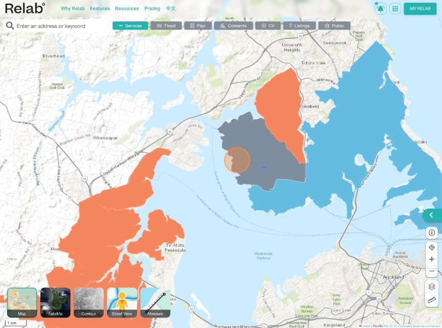
In our latest product update for property developers and investors, we're excited to announce the integration of Watercare’s network capacity map into our property analysis platform. This new feature arrives just as Watercare recently published their network capacity map, which has significant infrastructure implications affecting over 50,000 sites across the Auckland region.
Why This Matters for Property Developers
The recently announced network capacity constraints by Watercare have major implications for property development in Auckland. These constraints affect:
- 51,651 developable sites with water supply or wastewater service constraints
- Key areas including Hibiscus Coast, East Coast Bays, Birkenhead, Birkdale, Howick, Pakuranga and more.
Relab’s new feature helps you navigate these challenges with the most up-to-date and comprehensive property data and with confidence.
What's New in the Platform
1. Interactive Network Capacity Map Overlay
- Real-time visualisation of affected areas
- Integration with existing zoning and planning overlays
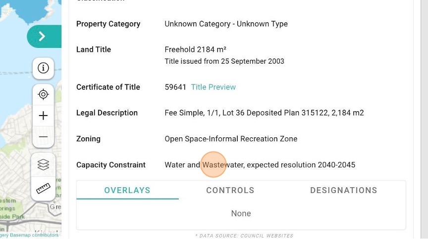
2. Capacity Constraint and Expected Resolution Timeframe
- Property-specific constraint information
- Expected infrastructure upgrade timeframes
How It Works
Simply log into your Relab account and you'll find the new infrastructure constraints layer in your mapping tools. Here's what you can do:
- Quick Property Screening using “Maps”
- Enter the address of subject site
- Click on “Services” icon on the top of the map
- If you see a solid colour appearing on the map for the subject site, that means it has capacity constraints according to Watercare’s network map
- Click on the map “Legend” icon, to find out if the constraint is related to Water, Wastewater or both.
2. Detailed Analysis using “Property Details Panel”
- Referred to the “Property details panel” for a comprehensive set of property data for the subject site
- Find “Capacity Constraint” for details on the type of water network constraint as well as expected resolution timeframe.
How this New Feature Can Help You?
For Developers
- Save time during initial property screening
- Reduce due diligence costs
- Make better-informed investment decisions
- Plan development timelines more accurately
For Investors
- Understand infrastructure impacts on property value
- Identify strategic investment opportunities
- Better risk assessment
- More accurate long-term planning
Looking Ahead
As Auckland enters a transformative phase with Watercare's unprecedented $13.7 billion infrastructure investment over the next decade (including $6.8 billion specifically for housing growth), the development landscape is set to evolve significantly. Our new feature ensures you stay ahead of these changes and make informed decisions for your property portfolio.
For specific inquiries about development capacity, connect directly with Watercare at networkcapacity@water.co.nz or book a demo to see how our platform can help you navigate Auckland's evolving infrastructure landscape.
Get Started Today
Current subscribers can access this new feature immediately at no additional cost. New users can sign up for a free trial to experience how Relab can help to transform their property development strategy.
Additional Resources
- Watercare Press Release https://www.watercare.co.nz/home/about-us/latest-news-and-media/building-for-auckland-s-growing-water-needs
- Network Capacity in Auckland https://www.watercare.co.nz/builders-and-developers/consultation/network-capacity-in-auckland
- Watercare Builders and Developers page https://www.watercare.co.nz/builders-and-developers
Frequently Asked Questions About Infrastructure Constraints
Understanding Constraints & Our Platform
Q: How accurate is your infrastructure constraint data?
A: Our platform syncs directly with Watercare's official data and is updated regularly.
Q: How do I check if my property is affected by infrastructure constraints?
A: Simply enter your property address in our platform's search bar and click the Services Overlay. Our system will show you any infrastructure constraints from Watercare, including water and wastewater capacity, along with expected resolution timeframes.
Q: Can your platform help me understand the severity of constraints?
A: Yes. Our detailed property reports show the specific type of constraint (water/wastewater/both), and Watercare’s expected resolution timeframes.
Development Planning & Constraints
Q: I'm planning to build in a constrained area - what should I do?
A: First, use our platform to understand the specific constraints affecting your site. Then contact Watercare at networkcapacity@water.co.nz for specific guidance if it’s in a constrained area.
Q: I already have building consent in a constrained area - am I affected?
A: No. If you already have building consent, you're not impacted by these constraints.
Q: I have resource consent but no building consent yet - what now? A: Use our platform to:
- Check whether capacity constraints impact your property
- Check upgrade timeframes
- Then contact Watercare at networkcapacity@water.co.nz for specific guidance.
Technical & Infrastructure Questions
Q: The map shows no capacity constraints in my area - does this guarantee service availability?
A: Not necessarily. Our platform can help you:
- Identify local street-level constraints
- Review nearby development impacts
- Generate reports for resource consent applications
- Assess potential local network upgrade requirements
Q: Can I build alternative wastewater solutions in constrained areas?
A: Watercare may not support wastewater tankering or off-peak pumping arrangements. Our platform can help you:
- Identify areas with existing infrastructure
- Find alternative development sites
- View infrastructure upgrade timelines
- Assess development feasibility
Using Our Platform Effectively
Q: How often is your constraint data updated?
A: Our platform syncs with Watercare's updates monthly.
Q: Can your platform help me find unconstrained areas for development?
A: Yes! Our advanced search features allow you to:
- Filter areas by infrastructure availability
- View upcoming infrastructure upgrades
- Compare development potential across different areas
- Generate comprehensive site reports
Future Development & Planning
Q: Can I secure future infrastructure capacity for my development?
A: No, Watercare cannot 'hold' network capacity. However, our platform can help you:
- Track infrastructure upgrade progress
- Monitor development activity in your area
- Plan project timelines around infrastructure improvements
Need More Help? Contact our support team for a personalised demo of how to use these new features effectively for your development planning.
Note: While we strive to provide the most accurate and up-to-date information, we recommend verifying critical decisions with Watercare and relevant authorities.