
For Agents
11 min read
Easily Uncover Qualified Development Sites with Relab’s Property Insight Tool
Simplify your search for the perfect development project with Relab's property insight tool
Streamline your preliminary property research with Relab. Instantly assess properties for development viability, including zoning, underground services, potential hazards, site elevation, and title and ownership details —all in one place.
Quick Development Due Diligence
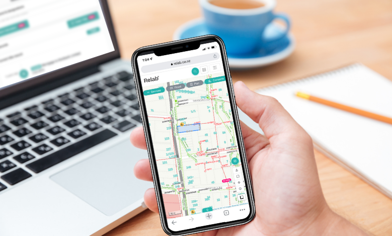
Spend less time sifting through potential sites and more time focusing on the development sites with true potential. Leverage our advanced mapping tool to view; proximity and diameter of services, council zoning, land contours, and high-resolution satellite imagery all in one view.
Check Development Feasibility
Check Nearby Development Consents
Gain insights into nearby building and resource consents to find upcoming competing developments which could impact your feasibility to develop a nearby property. Relab provides insights into approved building and resource consents that have been granted on nearby properties so you can save time and cost before ordering property files.
Check Nearby Building & Resource Consents
Relab the All in One Property Development Tool
Forget the hassle of navigating multiple sites for zoning regulations, flooding risks, sloping land, and the availability of underground services. Relab’s property development tool provides a complete overview in one easy-to-use platform, so you can quickly scan sites for development potential from any device.
Try Relab for Free
How to Evaluate Development Viability:
- Start with an Address: Enter your target property address into the Relab search panel.
- Discover Key Insights: Utilise our advanced mapping features for a comprehensive overview at a glance. Toggle layers for detailed insights into zoning, service proximity, environmental hazards, and more.
- Understand Legal Constraints: Access detailed insights into title types, protected trees, and other significant factors through Relab’s property panel.
- Visual Assessment Tools: Use high-resolution satellite imagery for a thorough preliminary site assessment and environmental context.
- Gauge the Competitive Landscape: Explore approved consents on neighbouring properties to understand the area's development trends and potential impacts on your project.
Transform the way you find properties with subdivision potential
With Relab, streamline your preliminary research, saving valuable time and advancing your projects with confidence. From uncovering hidden opportunities to conducting comprehensive due diligence, Relab is your indispensable partner in property development research.
Maximising Development Opportunities with Relab
At Relab, we understand the complexities and challenges of property development. Designed for developers at every level, Relab streamlines the initial stages of property development. Whether you're exploring new ventures or expanding your portfolio, Relab is your essential toolkit.
At the outset of your property development journey, evaluating a property's potential is crucial. Relab simplifies this first step, from preliminary checks to in-depth feasibility studies, ensuring you make informed decisions from the start.
Step away from traditional property evaluation that involves fragmented, time-intesive research methods, Relab offers a unified solution. With advanced mapping, detailed property insights, and a wealth of development data at your fingertips, Relab reduces the complexity of property evaluation. Our platform consolidates legal, physical, and infrastructural data, alongside valuable market insights, making Relab the superior choice for efficiency and accuracy.
Why Choose Relab for Property Development:
Relab not only saves you time by aggregating critical development data but also empowers you with precision tools to swiftly identify and assess high-potential properties. Streamline your research, search for hidden opportunities, and navigate your development projects with speed and confidence. Our premium tool is designed specifically for property developers, searching for both listed and unlisted properties to perfectly align with development strategy.
With Relab Premium, property development research is no longer a barrier to success. You'll be equipped to discover, evaluate, and act on development opportunities faster than your competition.
More Relab Tools:
Advanced Search Filters - Search for properties with high development potential
Geospatial Map - for precision satellite imagery of the site
Measurement Tool & boundary measurements - evaluate boundary measurements
Subdivision Calculator and Feasibility Tool- create your own
Liquifaction Map - Assess development risks in Christchurch
Frequently Asked Questions:
How is a development site evaluated?
The evaluation of a development site involves a thorough analysis that looks at zoning regulations, potential environmental hazards, site elevation, and overall development feasibility. We dig into a variety of essential data points to provide a comprehensive picture that helps you make informed decisions.
How can I ascertain ownership and title details?
With Relab, getting ownership and title details is straightforward. For all Pro, Premium & Platinum users, a simple address search provides immediate access to title previews, certificate of title numbers, and ownership specifics. Our direct integration with the Land Information New Zealand (LINZ) database also allows you to obtain full titles for $12 inclusive.
Does Relab offer updates on the status of resource and building consent applications?
Absolutely. Relab keeps you in the loop with the latest on approved resource and building consents in Auckland, Christchurch, and Queenstown, courtesy of our integration with their City Councils. This includes crucial dates and internal notes. For detailed insight, a full property file from the City Council is recommended. Premium Users benefit from the option to set up notifications for newly approved consents, ensuring they’re always informed.
What capabilities does Relab provide for evaluating feasibility outcomes of different development scenarios?
For Auckland developers, our subdivision calculator is a game-changer. It provides a framework to help predicts the financial outcomes of various development options, offering critical insights that support strategic planning and maximise potential returns.
How does Relab aid in assessing development risks in earthquake-prone regions?
Leveraging data from Christchurch, Relab provides access to liquefaction risk maps, offering a clear view of potential earthquake hazards. This critical insight helps in evaluating risks and making safer investment decisions in earthquake-prone areas.
In what ways does Relab's advanced search function reveal unlisted properties with high development potential?
Relab Premium unlocks the power to discover high-potential, yet unlisted, properties. By defining specific search parameters such as site size, zoning, and available services, you can identify prime development opportunities that might otherwise remain hidden. This advanced search capability is an invaluable tool for developers looking to stay ahead in the market.