
For Agents
8 min read
How to Enhance Property Comparisons with the Polygon Tool in Relab
In the fast-paced world of real estate, accuracy and efficiency are paramount. One of the biggest challenges agents face when comparing properties is the limitation of traditional tools, such as the radius-based search. If you’ve ever tried to narrow down a specific area only to be overwhelmed by irrelevant listings, you’re not alone. Fortunately, Relab’s Polygon feature offers a solution to this problem, allowing real estate agents to customise property comparisons like never before. In this guide, we’ll explore how the Polygon works, its benefits, and how it can be applied in real-world scenarios.
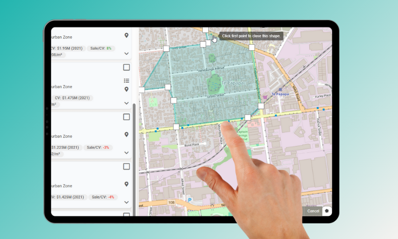
The Polygon Tool is a feature within Relab’s CMA tool that enables agents to draw custom boundaries for property comparisons. Unlike the radius tool, which creates a circular boundary around a central point, the Polygon allows agents to outline a specific area with any shape or size, making it ideal for defining irregularly shaped regions or neighbourhoods.
Using the Polygon is straightforward. Follow these simple steps to draw your custom boundaries and start comparing properties like a pro:
After you’ve created a new circular radius or polygon, you may want to remove the default circular radius that was initially placed. Here’s how to do it:
The Polygon Tool is more than just a feature—it’s a powerful tool that offers several key benefits:
The Polygon Tool is a valuable tool for real estate agents looking to enhance their property comparisons. By offering precise control over the areas you’re analysing, it helps you provide better recommendations, improve the accuracy of your market analysis, and ultimately serve your clients more effectively.
Make your property appraisals efficient. New to Relab? Try Relab free with a 14-day trial and see how our CMA design studio tool can help you make your comparative market analysis more credible.
Want to see the platform in action first? Book a personalised 20-minute demo to discover how Relab can improve your agency's workflow when creating comparable sales reports.
What is the Polygon Tool?
The Polygon Tool is a feature within Relab’s CMA tool that enables agents to draw custom boundaries for property comparisons. Unlike the radius tool, which creates a circular boundary around a central point, the Polygon allows agents to outline a specific area with any shape or size, making it ideal for defining irregularly shaped regions or neighbourhoods.
How to Use the Polygon Tool
Using the Polygon is straightforward. Follow these simple steps to draw your custom boundaries and start comparing properties like a pro:
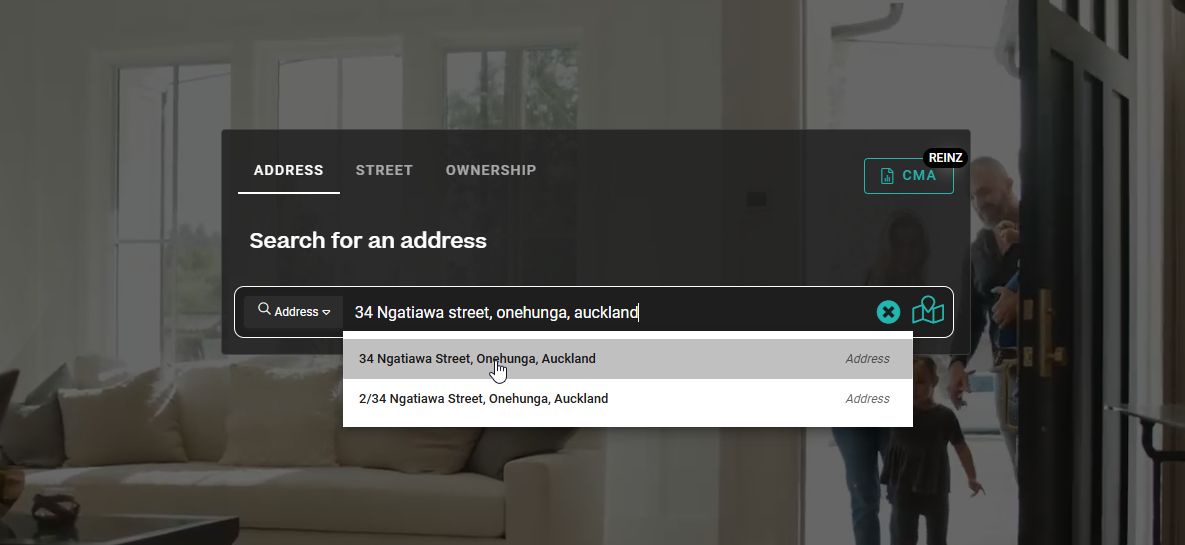
- Search for a Property Address: Start by searching for the property you’re working with.
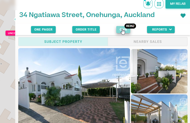
- Click the CMA Button: Navigate to the property details page and click the CMA button at the top to open the Comparable Listings view.
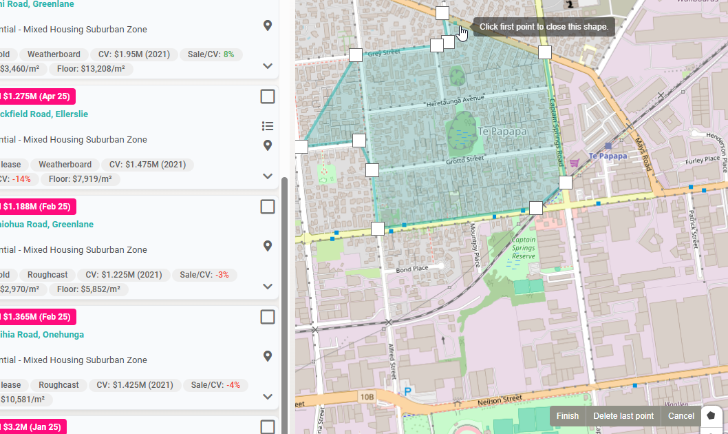
- Use the Polygon Tool: On the right-hand panel, select the Polygon. Click on the map to define the boundaries of your area, drawing a shape that suits the specific region you want to focus on. Relab will automatically display comparable properties based on your custom-defined polygon.
How to Delete the Circular Radius:
After you’ve created a new circular radius or polygon, you may want to remove the default circular radius that was initially placed. Here’s how to do it:
- Draw a New Shape: First, create a new radius (circular) or polygon to define the area you want to focus on.
- Click on the Circular Radius: Once you’ve drawn the new shape, click on the previous circular radius you want to delete.
- Trash Bin Icon: A Trash Bin icon will appear when the circular radius is selected.
- Click the Trash Bin Icon: Simply click the icon to remove the circular radius from the map.
Key Benefits of the Polygon Tool
The Polygon Tool is more than just a feature—it’s a powerful tool that offers several key benefits:
- Customisation: Unlike the radius tool, which can be restrictive, the Polygon Tool gives agents the freedom to define the area in any shape they choose. Whether it’s a rectangular neighbourhood or a jagged block of properties, the tool adapts to the needs of the agent.
- Better Alignment with Client Needs: Sometimes, clients have very specific preferences, like being closer to a park or a certain school district. The Polygon Tool allows agents to hone in on those needs by accurately outlining the desired areas, ensuring that clients receive property recommendations that truly match their criteria.
- Increased Efficiency: By eliminating irrelevant listings that don’t meet the area specifications, agents can focus their efforts on highly relevant properties, streamlining the comparison process and boosting client satisfaction.
Conclusion: Enabling Your Property Comparisons with the Polygon Tool
The Polygon Tool is a valuable tool for real estate agents looking to enhance their property comparisons. By offering precise control over the areas you’re analysing, it helps you provide better recommendations, improve the accuracy of your market analysis, and ultimately serve your clients more effectively.
Ready to Enhance Your CMA Reports?
Make your property appraisals efficient. New to Relab? Try Relab free with a 14-day trial and see how our CMA design studio tool can help you make your comparative market analysis more credible.
Want to see the platform in action first? Book a personalised 20-minute demo to discover how Relab can improve your agency's workflow when creating comparable sales reports.