
Is your property in a flood zone in Auckland? What you need to know
Welcome back to our series of articles where Relab takes you straight into the practical side of Auckland flood risk. In earlier pieces, we've unpacked the four main flood map layers and shown you how to use Council's GeoMaps for deeper analysis. Today, we're zooming out a bit and answering the question most owners and buyers really care about:
"Is my property in a flood zone – and what does that actually mean under PC120?"
The goal of this series is simple: give you practical tools and a solid understanding of what flood risk really means for your property – not just in terms of insurance and resale, but also how Auckland Council's Plan Change 120 (PC120) treats natural hazards.
Am I in a flood zone?
It's the question on everyone's lips – "Is my property a flood risk?" After the January 2023 storms and floods, awareness has skyrocketed – and rightly so. Insurers are more cautious, banks are asking harder questions, and savvy buyers are checking flood maps as part of basic due diligence.
On top of that, PC120 (Housing Intensification and Resilience) has updated the way the Auckland Unitary Plan manages natural hazards like flooding. Flood maps are now a key input into a risk-based framework that classifies natural hazard risk as Significant, Potentially tolerable, or Acceptable, with stronger rules where risk is high.
The bottom line? Understanding flood zones is no longer optional – it's a necessity.
PC120: why flood maps now matter even more
How PC120 changed the flood risk rules
PC120 proposes changes to the Auckland Unitary Plan to better manage significant risks from natural hazards, including flooding. It does three important things for flood risk:
- Introduces a risk management framework that classifies natural hazard risk as Significant, Potentially tolerable, or Acceptable, and ties different policy responses to each level.
- Updates how areas subject to natural hazards are identified and mapped, using the latest information on flooding, sea level rise and climate change.
- Signals that land at the greatest risk of flooding should have zoning that minimises exposure to risk (for example, more conservative zoning in very high-risk areas).
For you, that means the flood overlays you see in Relab, Flood Viewer and GeoMaps are not just "nice to know" – they're part of how council and consultants will assess what development is realistic on a site.
The tools to understanding risk (Relab + Council)
We've already covered the science and terminology in our article on the four types of flood risk in Auckland – floodplains, flood prone areas, overland flow paths and coastal inundation. With those basics under your belt, the next step is to know which tools to use to check a specific property.
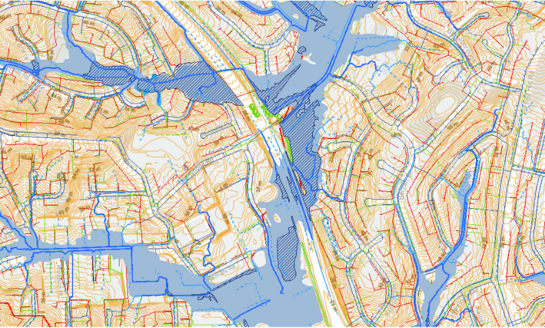
Relab brings several key map layers together so you can understand flooding risk quickly:
- Relab flood hazard layer (new) – a simple, user-friendly map view that shows floodplains, flood prone areas and overland flow paths for Auckland, based on the latest Council modelling that underpins the updated Natural Hazards (E36) framework under PC120. It's designed as a fast first pass on any property you're considering.
- Services overlay – displays underground infrastructure including stormwater and wastewater pipes, pump stations and other key services. This is especially useful if you're thinking about development or intensification, because large pipes can mean real constraints.
- Contours overlay – shows contour lines (elevations) across the property, making it easier to see which way water will naturally flow across the site and surrounding streets.
Used together, these Relab layers help property owners, buyers and professionals visualise flood risk, infrastructure and topography in one place, instead of juggling multiple websites.
Alternative tools
Relab is designed to make flood checks quick and intuitive, but it sits on top of – not instead of – Auckland Council's own tools. You should still know how to cross-check with them:
- Flood Viewer (Auckland Council) – a free, public tool that shows flood types on a map (floodplains, flood prone areas, overland flow paths and coastal inundation). It's easier to understand than GeoMaps and is a great cross-check against what you see in Relab.
- GeoMaps (Auckland Council) – another free tool that contains the same core flood layers as Flood Viewer, plus more technical information (flows, catchments, model dates, climate change assumptions). It's more complex, but extremely useful for engineers and more detailed due diligence.
- PC120 map viewer & property summary (Auckland Council) – a dedicated PC120 map viewer with a property summary showing the zone, management layers and any spatially identified qualifying matters (including where proposed flood-related QMs apply). This is the official place to see how PC120 is proposed to apply to a specific property.
Think of it like this:
- → Relab = fast, integrated screening for everyday use.
- → Flood Viewer = simple Council view of the same hazards.
- → GeoMaps = technical deep dive when you or your advisers need detail.
- → PC120 map viewer = PC120-specific context (zoning, intensification layers, qualifying matters).
Smart next steps
Use the maps, understand the data, and if in doubt, dig deeper. A simple workflow that works well in practice:
1. Screen the property quickly
- Turn on Relab's flood hazard layer, or use Auckland Council's Flood Viewer, and enter your property address.
- Check for floodplains, flood prone areas, overland flow paths and coastal inundation (coastal inundation is visible in Flood Viewer / GeoMaps rather than in Relab).
- Any blue shading on or near your property? Treat that as a prompt to investigate further.
2. Cross-check with GeoMaps and the PC120 viewer
- Use GeoMaps if you're comfortable with maps or working with professionals – it can show peak flows, catchment areas, model dates and climate change assumptions for hazards on or near your site.
- Open the PC120 map viewer and click on the property to see the PC120 property summary – this will show any spatially identified natural hazard qualifying matters that are relevant under PC120.
3. Consult with experts where needed
- If the property shows signs of any flood risk in these tools (especially floodplains or key overland flow paths), consider engaging a Chartered Professional Engineer or certified flood risk assessor.
- They can interpret the modelling in the context of PC120's risk framework and advise what may be realistic in terms of development, mitigation and consent requirements.
Wrapping it up
Flooding in Auckland is no longer a rare, once-in-a-lifetime event – and with PC120's new natural hazard framework, it's something council, insurers, lenders and buyers are all paying close attention to.
The good news is that you now have better tools than ever:
- Relab's flood hazard, services and contour overlays for quick, integrated checks.
- Auckland Council's Flood Viewer, GeoMaps and PC120 map viewer for deeper, official context.
Used together, they give you a clear, practical way to understand whether your property is in a flood zone and what that might mean for insurance, resale and future development.
For more on flood risk, PC120 and Auckland property due diligence, check out the other articles in this series, explore the resources available inside Relab, and – if you haven't already – take advantage of our free trial to see how your properties stack up.
Important note on PC120 (disclaimer)
Important note on PC120 (disclaimer)
This checklist summarises public information about Auckland flood maps, PC120 natural hazard provisions and council processes in general terms. It is general information only and is not planning, legal, engineering or financial advice.
PC120 is still progressing through submissions, hearings and decisions. Before making decisions about buying, selling or developing, always:
- Check the latest Auckland Council Flood Viewer, GeoMaps, PC120 map viewer and planning maps, and
- Get advice from a suitably qualified planner, engineer, legal and/or financial professional for your specific property.